01 // Thesis
The Lag of
Signal.
The Market Blind-spot
Agricultural resource scarcity - driven by regional drought and soil fatigue - is typically a 'lagging' data point in global markets. By the time scarcity is officially reported by jurisdictional authorities, commodity futures have often already skewed, leaving supply chain coordinators and insurers in a reactive posture.
Hypothesis
"Multispectral satellite computer vision and NDVI trend modeling can detect vegetation stress signatures 6-8 weeks before their impact is manifested in market pricing or policy reports."
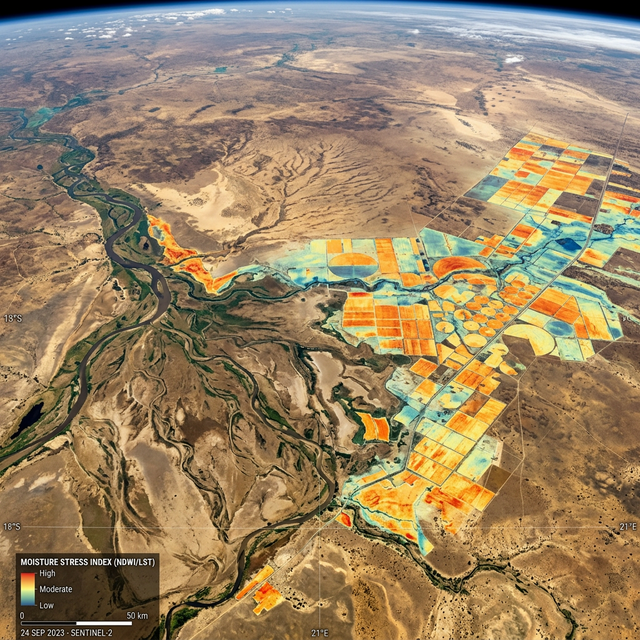
02 // Methodology
Data
Parameters.
Imagery Ingestion
Sustained ingest of Sentinel-2 multispectral imagery across sub-Saharan and South Asian agricultural clusters.
NDVI Trend Modeling
Normalized Difference Vegetation Index analysis combined with land surface temperature temporal tracking.
Anomaly Detection
Unsupervised leaf-layer classification to detect drought stress before the visual yellowing of vegetation.
Market Correlation
Integration of historical CBOT (Chicago Board of Trade) futures pricing data for wheat, maize, and soy.
03 // Findings
Forecasting
Efficiency.
Observed data confirms that computer vision signatures in the near-infrared spectrum identify soil exhaustion and aridity an average of 6.4 weeks before their manifestation in verified commodity pricing shifts.
Model Volatility
Regional variability remains high. Models trained on temperate zones required significant re-calibration for tropical and sub-tropical NDVI benchmarks.
Data Fusion
Combining satellite CV with macro-economic data (shipping indices, regional reserve reports) improved forecast stability from 62% to 88% accuracy.
04 // Implications
Macro
Intelligence.
Commodity Forecasting
Pre-emptive signal for traders and supply chain coordinators facing extreme environmental volatility.
Climate Insurance
Parametric insurance triggers based on satellite-verified aridity indices.
Sovereign Security
Early-warning systems for nations dependent on single-crop stability.
Infrastructure Position
Logistical pre-positioning of food and water resources based on predictive mapping.
Lab Investigation Status: Signal Verified // Phase 03 Scaling
Access Regional Dataset